![](/images/other/stat-length.png)
![Trail On foot Světlá pod Ještědem - NS Ještědské vápence - Photo](https://media.geolcdn.com/t/1900/400/3173d951-65db-4506-ac79-bb2c254a027f.jpeg&format=pjpeg&maxdim=2)
NS Ještědské vápence
SityTrail - itinéraires balisés pédestres
Tous les sentiers balisés d’Europe GUIDE+
![Length](/images/other/stat-length.png)
Length
7.5 km
![Max alt](https://static1.geolcdn.com/siteimages/upload/files/1508320355ic_sort_altitude_max_24dp.png)
Max alt
789 m
![Uphill gradient](https://static1.geolcdn.com/siteimages/upload/files/1508320355ic_sort_den_pos_24dp.png)
Uphill gradient
338 m
![Km-Effort](/images/other/stat-length.png)
Km-Effort
12.2 km
![Min alt](https://static1.geolcdn.com/siteimages/upload/files/1508320355ic_sort_altitude_min_24dp.png)
Min alt
432 m
![Downhill gradient](https://static1.geolcdn.com/siteimages/upload/files/1508320355ic_sort_den_neg_24dp.png)
Downhill gradient
380 m
![Boucle](https://static1.geolcdn.com/siteimages/upload/files/16400158638029165_repeat_loop_refresh_sync_direction_icon.png)
Boucle
No
Signpost
Creation date :
2025-02-07 07:52:49.139
Updated on :
2025-02-07 07:52:49.139
![On foot](https://static1.geolcdn.com/sitytour/trail-icons/100.png)
2h46
Difficulty : Easy
![Scan this QR Code to open this trail in the SityTrail application](https://capi.geolives.com/qq0zvz2zws4bq2lad0pu/sitytour/trails/4344889/qr.png?size=200)
FREE GPS app for hiking
About
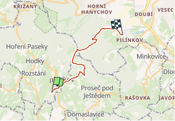
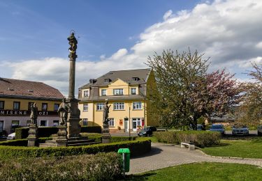
Trail On foot of 7.5 km to be discovered at Northeast, Liberecký kraj, Světlá pod Ještědem. This trail is proposed by SityTrail - itinéraires balisés pédestres.
Description
Trail created by cz:KČT.
dne 2014-12-07 značky jen na cedulích, ne podél cesty
Positioning
Country:
Czech Republic
Region :
Northeast
Department/Province :
Liberecký kraj
Municipality :
Světlá pod Ještědem
Location:
Unknown
Start:(Dec)
Start:(UTM)
498958 ; 5616615 (33U) N.
Comments
Trails nearby
![Trail On foot Kryštofovo Údolí - NS Hravé putování Ještědským lesem - Photo](https://media.geolcdn.com/t/375/260/6340d842-99c1-4d56-accc-2626b0e1acf8.jpeg&format=jpg&maxdim=2)
![On foot On foot](https://static1.geolcdn.com/sitytour/trail-icons/100.png)
NS Hravé putování Ještědským lesem
On foot
Easy
Kryštofovo Údolí,
Northeast,
Liberecký kraj,
Czech Republic
![](/images/other/stat-length.png)
4.6 km | 5.9 km-effort
1h 19min
![](https://static1.geolcdn.com/siteimages/upload/files/16400158638029165_repeat_loop_refresh_sync_direction_icon.png)
No
![Trail On foot Liberec - NS Terasy Ještědu - Photo](https://media.geolcdn.com/t/375/260/43666708-f133-47f8-944a-d5a14efffbcb.jpeg&format=jpg&maxdim=2)
![On foot On foot](https://static1.geolcdn.com/sitytour/trail-icons/100.png)
NS Terasy Ještědu
On foot
Easy
Liberec,
Northeast,
Liberecký kraj,
Czech Republic
![](/images/other/stat-length.png)
9 km | 13.6 km-effort
3h 5min
![](https://static1.geolcdn.com/siteimages/upload/files/16400158638029165_repeat_loop_refresh_sync_direction_icon.png)
No
![Trail On foot Světlá pod Ještědem - NS Karolíny Světlé - Photo](https://media.geolcdn.com/t/375/260/e0a5cff2-e21e-4320-988b-f99f6ace981d.jpeg&format=jpg&maxdim=2)
![On foot On foot](https://static1.geolcdn.com/sitytour/trail-icons/100.png)
NS Karolíny Světlé
On foot
Easy
Světlá pod Ještědem,
Northeast,
Liberecký kraj,
Czech Republic
![](/images/other/stat-length.png)
7 km | 9.6 km-effort
2h 10min
![](https://static1.geolcdn.com/siteimages/upload/files/16400158638029165_repeat_loop_refresh_sync_direction_icon.png)
Yes
![Trail On foot Osečná - NS K pramenům - Photo](https://media.geolcdn.com/t/375/260/2ed1145e-e7c5-46fc-acbb-cdc17dc9b741.jpeg&format=jpg&maxdim=2)
![On foot On foot](https://static1.geolcdn.com/sitytour/trail-icons/100.png)
NS K pramenům
On foot
Easy
Osečná,
Northeast,
Liberecký kraj,
Czech Republic
![](/images/other/stat-length.png)
3.1 km | 3.7 km-effort
50min
![](https://static1.geolcdn.com/siteimages/upload/files/16400158638029165_repeat_loop_refresh_sync_direction_icon.png)
Yes
![Trail On foot Kryštofovo Údolí - [M] Výpřež - Novina - Photo](https://media.geolcdn.com/t/375/260/71803f80-2c0c-496d-ad1d-7e0e8f6a53b1.jpeg&format=jpg&maxdim=2)
![On foot On foot](https://static1.geolcdn.com/sitytour/trail-icons/100.png)
[M] Výpřež - Novina
On foot
Easy
Kryštofovo Údolí,
Northeast,
Liberecký kraj,
Czech Republic
![](/images/other/stat-length.png)
4.1 km | 5.4 km-effort
1h 13min
![](https://static1.geolcdn.com/siteimages/upload/files/16400158638029165_repeat_loop_refresh_sync_direction_icon.png)
No